Land & Contour Survey

Land & Contour Survey
Our services encompass topographic land surveys and contour surveys, both of which can be offered separately. Our topographic surveys provide a comprehensive overview of your land's features, while contour surveys precisely outline elevation changes. Additionally, we provide all survey results in CAD format for easy integration into your design and planning processes, whether you choose one or both of these services. This flexibility ensures that we meet your specific project needs.
Client Projects
Tarapur 500 Acres
Panvel 250 Acres
Ghatkopar-Versova 500 Acres
Wankhede Stadium 7 Acres
Key Features
75,000 Ha. Land Surveyed
200+ Satisfied Clients
Cadastral & Revenue Survey
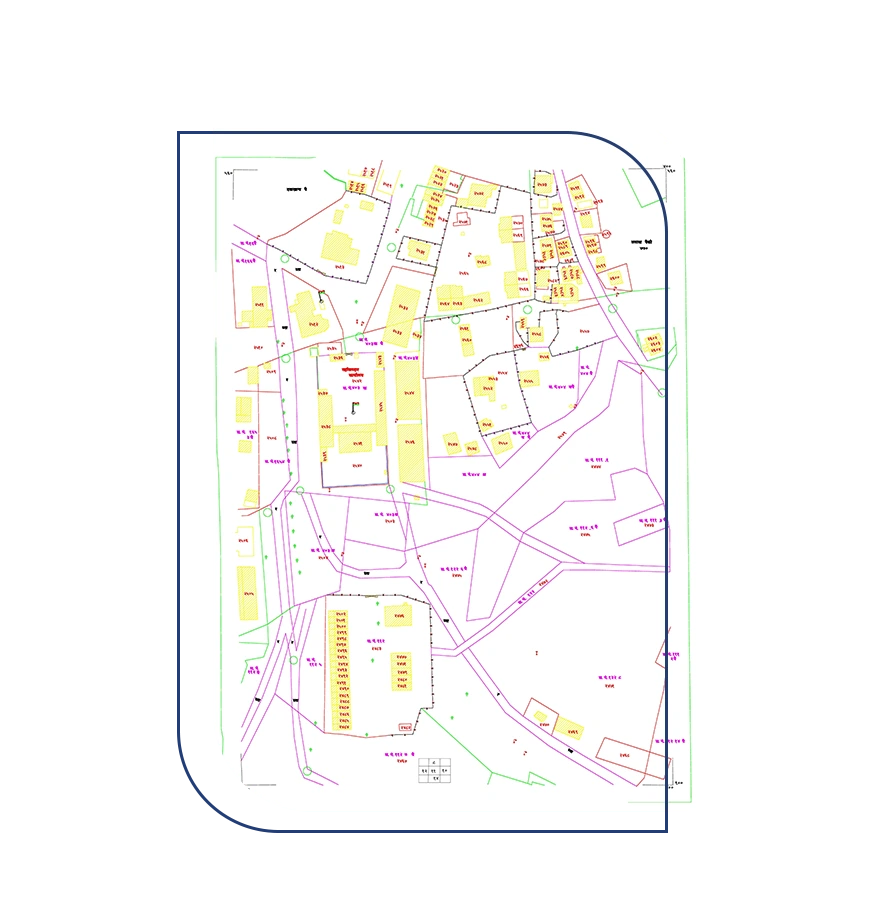
Cadastral & Revenue Survey
Our surveying services include cadastral surveys, which are essential for understanding land ownership and property boundaries. These services provide a comprehensive understanding of land boundaries, easements, and encumbrances. With our meticulous approach and advanced surveying techniques, we ensure that our clients have a crystal-clear view of their land's legal and physical dimensions including the collection of revenue data from state revenue departments such as 7/12 abstract (saat bara), 8A Abstract, Village Maps, Gut Book, Gut Scheme, Fer Far, City Survey Sheets, Property card, and all other relevant revenue documents for cadastral and revenue work. Additionally, our revenue survey services address the complexities of revenue assessment. Our team, including experts with experience in state revenue departments, understands the details involved.
Client Projects
Jaigarh Port Ratnagiri 2500 Acres
Solapur - Osmanabad Central Railway 80 Kms
Thane - Diva Central Railway 10 Kms
Boisar 150 Acres
Key Features
Extensive Revenue Records Database
25+ Years of Land Revenue Expertise
Gis-Gps Survey

Gis-Gps Survey
Our GIS GPS survey service sets the standard for precision and accuracy in geographic data collection. Equipped with the latest DGPS (Differential Global Positioning System) technology and the latest software applications, we provide a cutting-edge solution for your mapping and surveying needs. Our modern equipment ensures that every data point is captured with unparalleled precision, allowing for highly detailed and reliable geospatial information. Whether you're in need of land surveys, asset management, environmental mapping, or any other geospatial project, our GIS GPS survey service, powered by advanced technology and compatible software, guarantees a level of quality that exceeds expectations.
Client Projects
MBMC 19520 Acres
Navi Mumbai 24650 Acres
Wana River Wardha 25 Kms
MCGM Region 1000 Kms
Key Features
Cutting-Edge Surveying Equipment & Software Highly Skilled & Trained
Highly Skilled & Trained Professionals
Route & Final Location Survey

Route & Final Location Survey
Our route and final location survey service is essential for the efficient development of roads, railways, high-tension power lines, gas lines, water supply networks, sewerage systems, and mobile tower installations. We provide expert planning and precise surveys to identify optimal routes and locations for these vital infrastructure projects, ensuring their success and sustainability.
Client Projects
Talegaon - Kalwa 14 kms
Optical Fibre Cable Kalyan - Murbad 31 kms
Jal Jivan Mission 3183 kms
Raigad 6.50 Kms
Key Features
Decades of Industry Knowledge
Effective Communication with Project-Affected Persons (PAPs)
Drone Survey
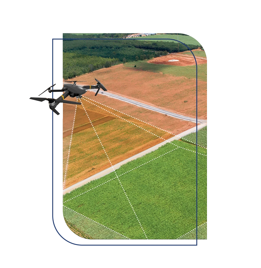
Drone Survey
Our drone survey service stands out with the expertise of DGCA-approved licensed qualified drone pilots, ensuring a top-tier experience. Leveraging cutting-edge drone technology, our fleet is registered with the Directorate General of Civil Aviation (DGCA), guaranteeing compliance with rigorous safety and regulatory standards. This commitment to excellence extends to our comprehensive range of surveying and mapping solutions, covering everything from land surveying and infrastructure inspections to environmental monitoring. By combining state-of-the-art drones, DGCA-approved licensing, and an unwavering dedication to safety and precision, we've become the go-to choice for unparalleled aerial insights in high-quality survey services.
Client Projects
Pen 300 Acres
Uttan 250 Acres
Virar 250 Acres
Poladpur 870 Acres
Key Features
Trained Drone Pilots
Over 1000 Hectares Surveyed by Our Team
SRA Survey
-copy.webp)
SRA Survey
As an empanelled agency within the (Slum Rehabilitation Authority) SRA Mumbai, we offer comprehensive SRA surveys tailored to your specific needs. Our services encompass door-to-door biometric surveys and topographic surveys, ensuring a detailed understanding of the project area in alignment with both client and SRA requirements. What sets us apart is our commitment to precision, with all survey data submissions in the WGS 84 grid, meticulously GIS-mapped and coordinates referenced to the SRA's base stations. This dedication to accuracy and adherence to SRA standards make us the trusted choice for SRA surveys in the Mumbai Metropolitan Region, facilitating effective slum rehabilitation and urban development initiatives.
Client Projects
Andheri 14 Acres
Thane 09 Acres
Malad 05 Acres
Kurla 08 Acres
Key Features
Government Empanelment
Pioneering in Mumbai
Licensed Surveyor Site Elevation Certificate

Licensed Surveyor Site Elevation Certificate
Our specialized services involve certifying precise plot coordinates and site elevation, authenticated by an experienced licensed surveyor. This authenticated certificate is crucial for securing various building approval certifications. Additionally, we present all survey data in CAD format, facilitating smooth integration into your design and planning processes and ensuring adherence to rigorous authentication standards.
Client Projects
Vikhroli 35 Acres
Thane 05 Acres
Mahim 05 Acres
Thane 02 Acres
Key Features
Expert Liaison Capabilities
Proficient in Submissions & Fillings


